The landscape of civil engineering has been transformed by the advent of powerful geospatial technologies. Geographic Information Systems (GIS), Global Positioning Systems (GPS), and Remote Sensing (RS) are no longer niche tools but integral components for planning, design, construction, and management of infrastructure projects. These technologies enable precise data acquisition, intelligent spatial analysis, and dynamic visualization, fundamentally enhancing decision-making and efficiency in the built environment.
Geographic Information System (GIS)
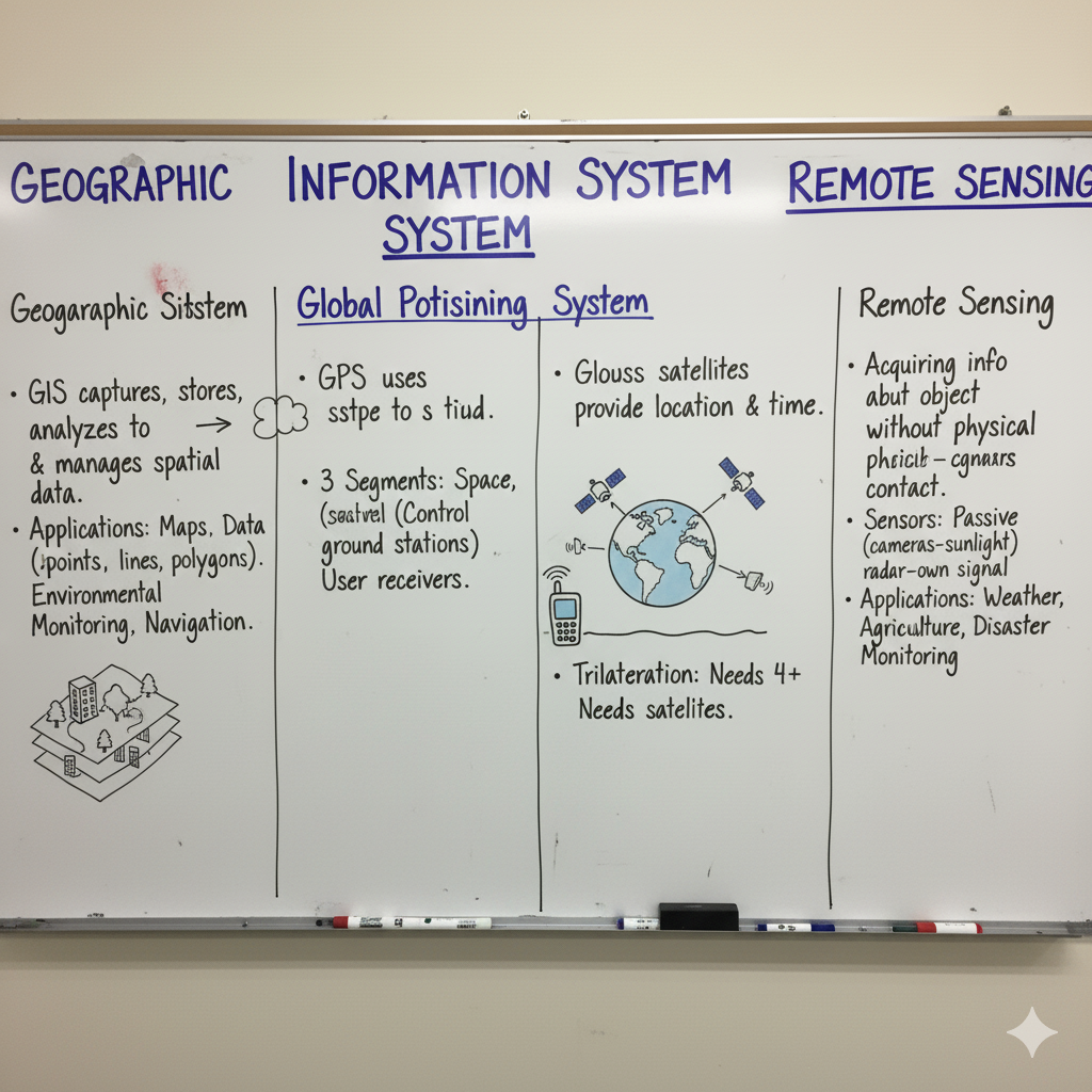
GIS is a powerful computer-based system designed to capture, store, manipulate, analyze, manage, and present all types of geographical data. It links spatial data (where things are) with attribute data (what things are like).
Core Components of GIS:
- Hardware: Computers, scanners, digitizers, plotters, etc.
- Software: GIS specific applications (e.g., ArcGIS, QGIS) for data input, storage, analysis, and output.
- Data: Spatial data (maps, coordinates) and attribute data (tables, statistics).
- People: GIS specialists, users, and data collectors.
- Methods: Procedures, workflows, and rules for effective GIS implementation.
Key Functions & Applications in Civil Engineering:
| Function | Application Area |
|---|---|
| Data Capture & Input | Digitizing paper maps, converting satellite images to spatial data. |
| Data Storage & Management | Organizing large spatial databases (e.g., land records, utility networks). |
| Data Manipulation & Analysis | Overlay analysis, buffer analysis, network analysis, site suitability analysis. |
| Data Output & Presentation | Generating thematic maps, 3D visualizations, reports for planning and presentation. |
| Site Selection | Identifying optimal locations for new projects (e.g., landfills, industries, residential areas) based on multiple criteria. |
| Urban Planning & Management | Mapping urban growth, utility infrastructure management (water, sewer, power lines). |
| Environmental Impact Assessment | Analyzing land use, pollution spread, ecological sensitivity for sustainable development. |
| Transportation Planning | Optimizing road networks, traffic flow analysis, route planning for logistics. |
| Disaster Management | Mapping flood zones, earthquake risk areas, and planning emergency response routes. |
Global Positioning System (GPS)
GPS (specifically NAVSTAR GPS, developed by the U.S.) is a satellite-based radionavigation system that provides precise positioning, velocity, and time information to a user with a GPS receiver anywhere on Earth, or in orbit, with an unobstructed line of sight to four or more GPS satellites.
Three Segments of GPS:
- Space Segment: Consists of 31 active satellites orbiting Earth in six different orbital planes. They continuously transmit radio signals.
- Control Segment: A global network of ground stations that track the satellites, monitor their health, and update their navigation data (ephemeris and clock corrections).
- User Segment: Comprises all GPS receivers that pick up signals from satellites and compute their position, velocity, and precise time.
Working Principle: Trilateration from Satellites
GPS receivers determine position by precisely measuring the time it takes for signals from multiple satellites to reach the receiver. Knowing the exact position of the satellites (from ephemeris data) and the signal travel time, the receiver calculates the distance to each satellite. By measuring distances to at least four satellites, the receiver can determine its 3D position (latitude, longitude, and altitude) and time.
Applications in Civil Engineering:
| Application Area | Benefit |
|---|---|
| Surveying & Mapping | Rapid and accurate establishment of control points, topographical surveys, cadastral surveys. |
| Construction Layout | Precise positioning of construction elements (foundations, columns, pipelines) and machine control (e.g., graders, excavators). |
| Monitoring Structural Deformation | Precise monitoring of bridges, dams, and tall buildings for subtle movements or settlement over time. |
| Site Grading & Earthwork | Guidance for excavation and fill operations, ensuring accurate terrain shaping. |
| Geological & Geotechnical Investigations | Mapping geological features, landslide monitoring, and seismic activity tracking. |
Remote Sensing (RS)
Remote Sensing is the art and science of acquiring information about an object, area, or phenomenon without coming into physical contact with it. This is typically done by detecting and measuring emitted or reflected electromagnetic radiation.
Basic Process of Remote Sensing:
- Energy Source: Illuminates the target (Sun for passive, sensor itself for active).
- Radiation & Atmosphere: Energy interacts with the atmosphere and then with the target.
- Interaction with Target: Energy is reflected, absorbed, or transmitted by the target.
- Recording of Energy by Sensor: Sensor on a platform (satellite, aircraft) records the energy.
- Transmission, Reception & Processing: Data is transmitted to ground stations, processed into images.
- Interpretation & Analysis: Images are analyzed to extract information.
Types of Remote Sensing:
- Passive Remote Sensing: Detects natural radiation (e.g., sunlight reflected from Earth’s surface, thermal emission). Examples: Landsat, Sentinel satellites.
- Active Remote Sensing: Emits its own energy and detects the backscattered energy. Examples: Radar, LiDAR (Light Detection and Ranging).
Applications in Civil Engineering:
| Application Area | Benefit |
|---|---|
| Topographic Mapping & DEM Generation | Creating digital elevation models (DEMs) and detailed contour maps, especially for large, inaccessible areas. |
| Land Use / Land Cover Mapping | Classifying and monitoring changes in land use for urban planning, environmental assessment, and resource management. |
| Infrastructure Monitoring | Detecting subtle ground movements, assessing structural health of bridges/dams, monitoring deforestation for resource extraction. |
| Hydrology & Water Resources | Mapping flood inundation, monitoring reservoir levels, assessing snow cover for water supply predictions. |
| Geological Mapping | Identifying rock types, geological structures, and potential fault lines for hazard assessment. |
| Coastal Zone Management | Monitoring shoreline changes, coastal erosion, and mapping submerged features. |
Interrelation & Synergies: How They Work Together
GIS, GPS, and Remote Sensing are often used collaboratively to maximize their individual strengths, creating a powerful ecosystem for geospatial analysis.
- GPS for Ground Truthing & Georeferencing: GPS provides accurate ground coordinates to calibrate remote sensing imagery (georeferencing) and validate interpretations made from satellite data (ground truthing).
- Remote Sensing as GIS Data Source: Satellite and aerial imagery from remote sensing serve as primary data inputs for creating and updating GIS databases (e.g., land cover maps, digital elevation models).
- GIS for Analysis & Visualization: GIS acts as the platform to integrate, analyze, and visualize data from both GPS (point data) and remote sensing (raster/image data), allowing for complex spatial queries and modeling.
- Integrated Mapping: A surveyor uses GPS to collect precise coordinates of critical points, which are then integrated into a GIS alongside remote sensing imagery for comprehensive mapping and analysis.
- Construction Monitoring: Remote sensing monitors site changes over time (e.g., progress of large earthworks), with GPS providing precise locations for ground measurements and GIS integrating all data for project management dashboards.
Advantages in Civil Engineering
The synergistic application of GIS, GPS, and Remote Sensing offers transformative benefits across the civil engineering lifecycle.
| Advantage | Description |
|---|---|
| Enhanced Accuracy & Precision | Provides highly accurate spatial data for design, construction, and monitoring, reducing errors and improving safety. |
| Improved Efficiency & Speed | Automates data collection and processing, allowing for faster surveys, mapping, and analysis, saving time and resources. |
| Cost Reduction | Minimizes fieldwork costs, reduces re-work, and optimizes resource allocation through better planning and management. |
| Better Decision Making | Facilitates complex spatial analysis and visualization, enabling data-driven decisions for optimal project outcomes. |
| Comprehensive Data Management | Centralizes and organizes vast amounts of spatial and attribute data, making it easily accessible and manageable throughout a project’s lifecycle. |
| Risk Mitigation | Aids in identifying environmental hazards, geological risks, and potential conflicts early in the project lifecycle, improving project resilience. |
| Sustainable Development | Supports environmental impact assessments, resource management, and optimized land use planning for sustainable infrastructure. |
GATE Exam Practice Questions & Explanations
Test your understanding of GIS, GPS, and Remote Sensing with these GATE-style questions, reflecting their importance in modern civil engineering.
1. Which component of GIS refers to the procedures, workflows, and rules for effective GIS implementation?
Answer: Methods
GIS is not just technology; it also includes the systematic approaches and guidelines for its effective use.
2. The space segment of GPS consists of:
Answer: A constellation of orbiting satellites transmitting radio signals.
The space segment is the network of satellites that broadcast the signals used by GPS receivers.
3. Remote sensing is the art and science of obtaining information about an object without:
Answer: Physically contacting it.
This is the defining characteristic of remote sensing, relying on non-contact measurement of electromagnetic energy.
4. Which type of remote sensing relies on detecting natural radiation, such as sunlight reflected from Earth’s surface?
Answer: Passive Remote Sensing
Passive sensors do not emit their own energy but instead measure ambient energy sources.
5. The primary principle by which a GPS receiver determines its position is:
Answer: Trilateration from satellites
By measuring distances to multiple satellites, the receiver can pinpoint its exact 3D location.
6. The ground segment of GPS is responsible for:
Answer: Tracking satellites, monitoring their health, and updating navigation data.
The control segment ensures the accuracy and integrity of the satellite signals and navigation messages.
7. Which GIS function involves combining multiple layers of spatial data to identify suitable locations for a new project?
Answer: Site suitability analysis (a form of data analysis/manipulation)
GIS excels at overlaying different spatial datasets (e.g., slope, soil type, land use) to find optimal areas.
8. LiDAR (Light Detection and Ranging) is an example of:
Answer: Active Remote Sensing
LiDAR systems emit laser pulses and measure the time taken for the reflected light to return, hence active.
9. What is the role of GPS in relation to remote sensing imagery?
Answer: Provides accurate ground coordinates for georeferencing and ground truthing.
GPS helps precisely align satellite imagery to real-world coordinates and verify features observed in the imagery.
10. The GIS component that includes maps, coordinates, and images is:
Answer: Data (Spatial data)
Data is the core input for any GIS analysis, combining location (spatial) and descriptive (attribute) information.
11. The primary purpose of GPS in construction layout is to:
Answer: Provide precise positioning of construction elements and guidance for machine control.
GPS receivers on machinery and survey instruments ensure that structures are built to exact design specifications.
12. Monitoring subtle ground movements for structural health assessment of bridges and dams is an application of:
Answer: GPS in Structural Monitoring
High-precision GPS receivers can detect millimetre-level displacements over time, crucial for early warning of structural issues.
Answer: Topographic Mapping & DEM Generation
Remote sensing techniques like LiDAR and photogrammetry are highly efficient for generating precise terrain models from aerial or satellite platforms.
14. What is the role of GIS in integrating data from GPS and Remote Sensing?
Answer: Acts as the platform to integrate, analyze, and visualize data from both sources.
GIS provides the tools to combine point data from GPS with raster imagery from remote sensing for comprehensive spatial analysis.
15. The earliest known GIS was created in the early 1960s by:
Answer: Dr. Roger Tomlinson
Dr. Tomlinson is widely recognized as the “Father of GIS” for his work on the Canada Geographic Information System (CGIS).
16. The user segment of GPS consists of:
Answer: All GPS receivers that pick up signals from satellites and compute position.
This segment includes all devices that utilize GPS signals for navigation and positioning.
17. Mapping flood inundation and monitoring reservoir levels are applications of:
Answer: Remote Sensing in Hydrology & Water Resources
Satellite imagery and radar data are particularly useful for observing water bodies and flood extents over large areas.
18. Which of the following is a key benefit of using GIS, GPS, and Remote Sensing collectively in civil engineering?
Answer: Enhanced accuracy and precision in spatial data.
The combined power of these technologies leads to highly reliable and precise data for all project phases.
19. If a remote sensing sensor emits its own energy and detects the backscattered energy, it is classified as:
Answer: Active Remote Sensing
Active sensors generate their own illumination, allowing them to operate independently of natural light sources.
20. GIS facilitates data-driven decision-making in civil engineering primarily through its capability for:
Answer: Complex spatial analysis and visualization.
By analyzing relationships between geographic features and presenting them visually, GIS empowers engineers to make informed and optimal decisions.