Plane table surveying is a graphical method of surveying where fieldwork and plotting are done simultaneously. It is particularly useful for small-scale mapping, topographical surveys, and reconnaissance surveys, offering a direct and immediate visualization of the terrain. This infographic explores the core principles, essential instruments, setup procedures, various survey methods, and the inherent advantages and limitations of plane table surveying, crucial knowledge for civil engineers.
What is Plane Table Surveying?
Plane table surveying is a method of surveying in which the map is prepared in the field itself. This unique approach means the measurements are taken and plotted concurrently, allowing the surveyor to directly observe and rectify any discrepancies on the spot.
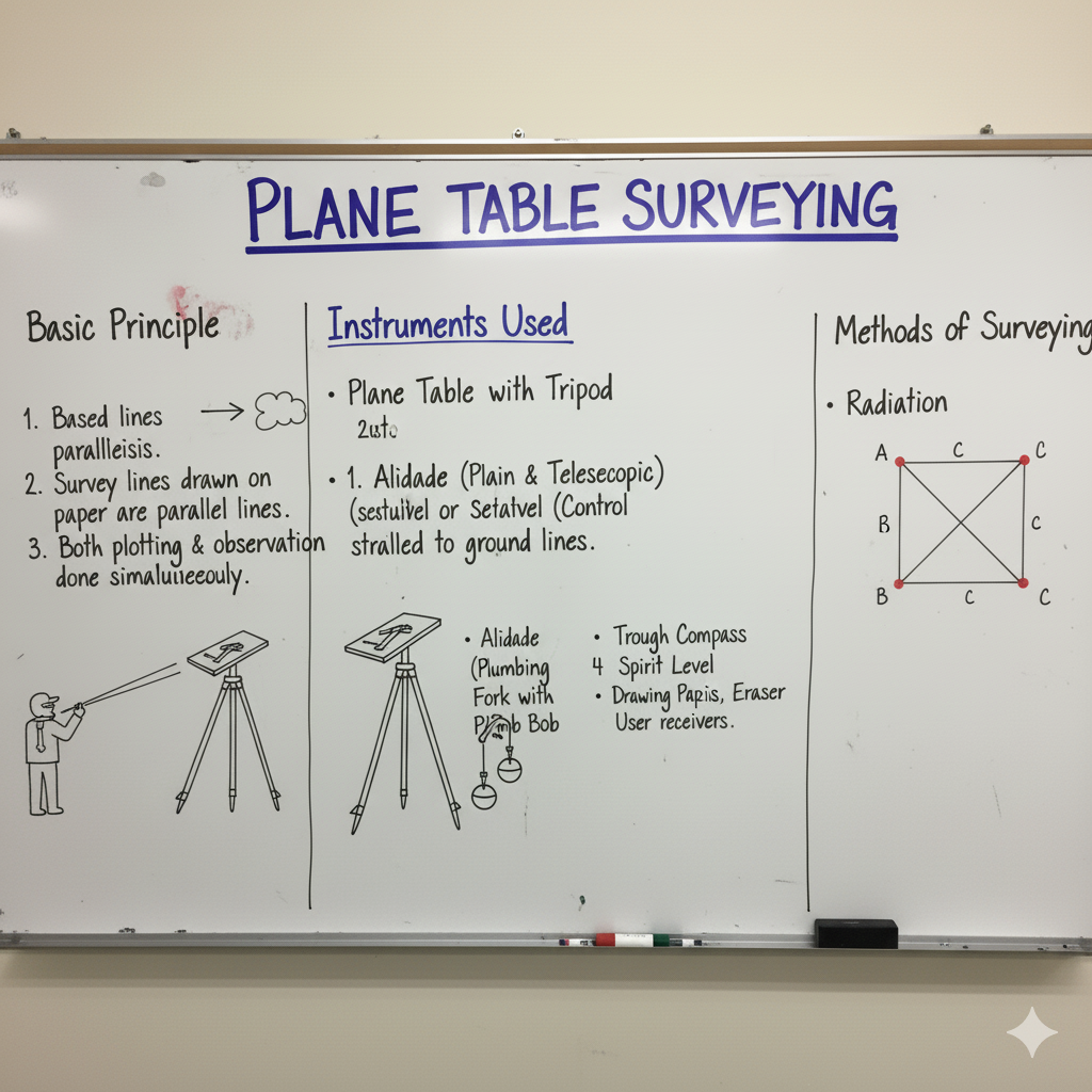
The fundamental principle is that **all lines drawn from the instrument station on the drawing sheet should be parallel to the corresponding lines on the ground**. This ensures that the orientation of the map remains consistent with the actual terrain being surveyed.
Instruments & Accessories in Plane Table Surveying
A specific set of instruments is required for successful plane table surveying, each playing a vital role in data collection and plotting.
| Instrument/Accessory | Description | Purpose |
|---|---|---|
| Plane Table | A drawing board, usually made of well-seasoned wood, mounted on a tripod. It can be rotated horizontally and clamped. | The surface on which the drawing paper is fixed for simultaneous plotting of fieldwork. |
| Alidade | A sighting rule with a sighting vane at one end and a fiducial edge (working edge) at the other. It may be plain (simple) or telescopic. | Used for sighting objects and drawing lines representing directions on the paper. The telescopic alidade also measures distances. |
| Tripod | A sturdy three-legged stand, typically adjustable in height, used to support the plane table. | Provides a stable and level platform for the plane table. |
| Trough Compass | A rectangular box containing a magnetic needle fixed with a pivot, used for orienting the table to the magnetic north. | Used to orient the plane table with respect to the magnetic meridian (magnetic north). |
| Spirit Level | A small tube containing spirit and a bubble, used to check and ensure the horizontal level of the plane table. | Ensures the plane table is perfectly horizontal for accurate plotting and sighting. |
| Plumbing Fork & Plumb Bob | A U-shaped metallic frame with a plumb bob suspended from its lower arm, used to transfer the ground station point to the paper and vice-versa. | Used for centering the table precisely over the ground station, ensuring the plotted point aligns with the actual station. |
| Drawing Paper | Good quality drawing paper, often waterproof or treated, firmly fixed to the plane table. | The medium on which the map is drawn directly in the field. |
| Waterproof Cover | A cover to protect the table and drawing from rain or moisture. | Protects the drawing and equipment from adverse weather conditions. |
| Drawing Accessories | Pencils (hard and sharp), eraser, drawing pins/clips, scales, and a measuring tape/chain. | For drawing, measuring distances, and fixing the paper to the board. |
Setting Up the Plane Table: Temporary Adjustments
Before commencing any observations, the plane table must undergo specific temporary adjustments at each station to ensure accurate results.
Steps for Temporary Adjustments:
- Centering:
- Using the plumbing fork and plumb bob, accurately position the plotted point on the drawing sheet directly over the corresponding ground station.
- Ensure the plumb bob hangs freely and directly over the ground peg.
- Levelling:
- Place the spirit level at various positions on the table, usually along two perpendicular directions.
- Adjust the tripod legs (or the table’s levelling screws, if provided) until the bubble of the spirit level is centered in both directions, indicating a perfectly horizontal table.
- Orientation:
- This involves aligning the plane table’s meridian (or a specific baseline) with the corresponding direction on the ground.
- It can be done using a trough compass (magnetic meridian), by back-sighting a known station, or by using a known baseline.
- The objective is to ensure that lines drawn on the paper are parallel to ground lines.
Methods of Plane Table Surveying
Various methods are employed in plane table surveying, each suited for different terrain conditions and mapping objectives.
| Method | Description | Applicability |
|---|---|---|
| Radiation Method | The instrument is set up at a single station. Lines are drawn from the plotted station point to various objects, and their distances are measured and plotted to scale. | Suitable for small areas, when the entire area is visible from one station. Simple and fast. |
| Intersection Method | Used when objects cannot be directly chained (e.g., across a river). Lines of sight are drawn to the object from two different plane table stations, and their intersection point fixes the object’s position. | Ideal for mapping inaccessible points or large areas from a few stations. |
| Traversing Method | A series of connected lines are surveyed, forming a traverse. The plane table is moved from one station to the next, orienting at each, and plotting the lines. | Suitable for long, narrow strips of land (e.g., roads, rivers) or when the area is too large for radiation/intersection. |
| Resection Method | Used to determine the plotted position of the instrument station on the map by sighting at least two (preferably three) well-defined objects whose positions are already plotted on the map. | Crucial for establishing the current instrument station’s position when it’s unknown or for filling in details after a main traverse. Common methods include Two-Point and Three-Point Problem. |
Advantages & Disadvantages of Plane Table Surveying
Understanding the pros and cons helps in deciding when plane table surveying is the most appropriate method.
| Aspect | Advantages | Disadvantages |
|---|---|---|
| Fieldwork & Plotting | Fieldwork and plotting are done simultaneously, reducing errors and saving time. | Not suitable for wet weather conditions or very hot climates (paper distortion). |
| Error Detection | Errors can be detected and corrected on the spot, preventing cumulative errors. | Cannot be used in densely wooded areas or where many obstructions exist. |
| Missing Details | No missing details as mapping is done in the field directly. | Requires frequent shifting of the table, making it tiring for large areas. |
| Accuracy | Generally accurate for small-scale mapping. | Less accurate than theodolite surveying for large-scale or precise work. |
| Cost | Relatively inexpensive compared to modern surveying methods. | Cannot be used for very precise work, e.g., city surveys or setting out long lines. |
GATE Exam Practice Questions & Explanations
Test your understanding of Plane Table Surveying methods, instruments, and applications with these GATE-style questions.
1. In plane table surveying, fieldwork and plotting are done:
Answer: Simultaneously
This is the defining characteristic of plane table surveying, where observations are plotted in real-time in the field.
2. The instrument used for sighting objects and drawing lines representing directions on the drawing paper in plane table surveying is the:
Answer: Alidade
The alidade features a sighting vane and a fiducial edge for drawing lines of sight directly onto the paper.
3. Which method of plane table surveying is used to determine the plotted position of the instrument station on the map by sighting known objects?
Answer: Resection Method
Resection is crucial for establishing the current unknown position of the plane table on the map by taking bearings to already plotted control points.
4. The least count of a plain alidade is typically:
Answer: Not directly applicable to least count in the same way as angular instruments; it’s a graphical tool.
Plain alidades are used for drawing lines and sighting; their precision is more about the sharpness of the fiducial edge and sighting accuracy rather than a fixed least count like a theodolite.
5. What is the primary purpose of a plumbing fork and plumb bob in plane table surveying?
Answer: To center the plane table precisely over the ground station.
The plumbing fork allows the plumb bob to hang from the plotted point on the table, ensuring it aligns with the ground peg.
6. Which method of plane table surveying is suitable for small areas where the entire area is visible from a single station?
Answer: Radiation Method
In this method, all points are sighted and measured directly from one setup of the plane table.
7. The temporary adjustment of the plane table that involves aligning its meridian with the corresponding direction on the ground is:
Answer: Orientation
Orientation ensures that the map on the table is aligned with the actual ground, maintaining parallelism.
8. A trough compass is used in plane table surveying for:
Answer: Orienting the table with respect to the magnetic meridian.
It helps align a drawn north line on the paper with the magnetic north direction on the ground.
9. Which method of plane table surveying is used when objects cannot be directly chained, relying on lines of sight from two different stations?
Answer: Intersection Method
Points are located by the intersection of rays drawn from two different instrument stations, common for inaccessible features.
10. One of the main advantages of plane table surveying is that:
Answer: Errors can be detected and corrected on the spot.
The real-time plotting allows the surveyor to immediately identify and resolve any plotting or measurement errors.
11. For achieving perfect horizontal level of the plane table, which accessory is used?
Answer: Spirit Level
The spirit level ensures the drawing surface is perfectly horizontal, which is critical for accurate sighting and plotting.
12. The method of plane table surveying suitable for long, narrow strips of land like roads or rivers is:
Answer: Traversing Method
Traversing involves moving the table from station to station, establishing a series of connected lines that follow the strip of land.
13. A disadvantage of plane table surveying is that it is not suitable for:
Answer: Wet weather conditions or very hot climates.
The drawing paper is susceptible to damage from moisture and distortion from excessive heat.
14. What is the fundamental principle of plane table surveying regarding lines drawn on the drawing sheet?
Answer: All lines drawn from the instrument station on the drawing sheet should be parallel to the corresponding lines on the ground.
This parallelism is key to accurately representing the ground features on the map directly.
15. The drawing paper used in plane table surveying should ideally be:
Answer: Of good quality and often waterproof or treated.
Durability and resistance to environmental factors are important for fieldwork.
16. The process of centering the plane table is done to ensure:
Answer: The plotted point on the drawing sheet is directly over the corresponding ground station.
Accurate centering is essential to ensure that all rays drawn from the plotted point correctly represent directions from the actual ground station.
17. Which accessory of a plane table is used to determine if the table is truly horizontal?
Answer: Spirit Level
The spirit level directly indicates whether the drawing surface is perfectly level, which is critical for accurate measurements and plotting.
18. One major limitation of plane table surveying is its unsuitability for:
Answer: Very precise work, e.g., city surveys or setting out long lines.
While good for small-scale mapping, its graphical nature and manual plotting limit its precision for high-accuracy engineering projects.
19. If the plane table is shifted from a known station to an unknown station, and its position on the map needs to be determined by sighting known features, which method is typically applied?
Answer: Resection Method
Resection is precisely for locating the instrument’s position on the map when it’s moved to a new, unplotted station.
20. What is a key advantage of plane table surveying regarding fieldwork and office work?
Answer: It combines both fieldwork and plotting, reducing the need for extensive office calculations and plotting.
This integration streamlines the surveying process, minimizing potential errors that can arise during data transfer and separate plotting stages.