Imagine transforming a complex, undulating landscape into a clear, actionable blueprint. Contouring is that powerful surveying technique, graphically rendering the Earth’s intricate three-dimensional relief onto a flat, two-dimensional map. By meticulously connecting points of equal elevation, contour lines unveil invaluable insights into terrain characteristics, slopes, and hidden drainage patterns. This infographic invites you to explore the fascinating fundamentals of contouring, unravel the essential properties of these lines, learn to interpret every subtle nuance of terrain, and discover the diverse, critical applications of contour maps in the world of civil engineering.
Contouring & Contour Interval: The Foundation of Terrain Mapping
A contour is an imaginary line on the ground surface connecting points of equal elevation. The meticulous process of tracing these crucial lines onto a map is known as contouring. It stands as the most effective and elegant method for depicting the vertical dimension of our planet’s surface on a convenient horizontal plane.
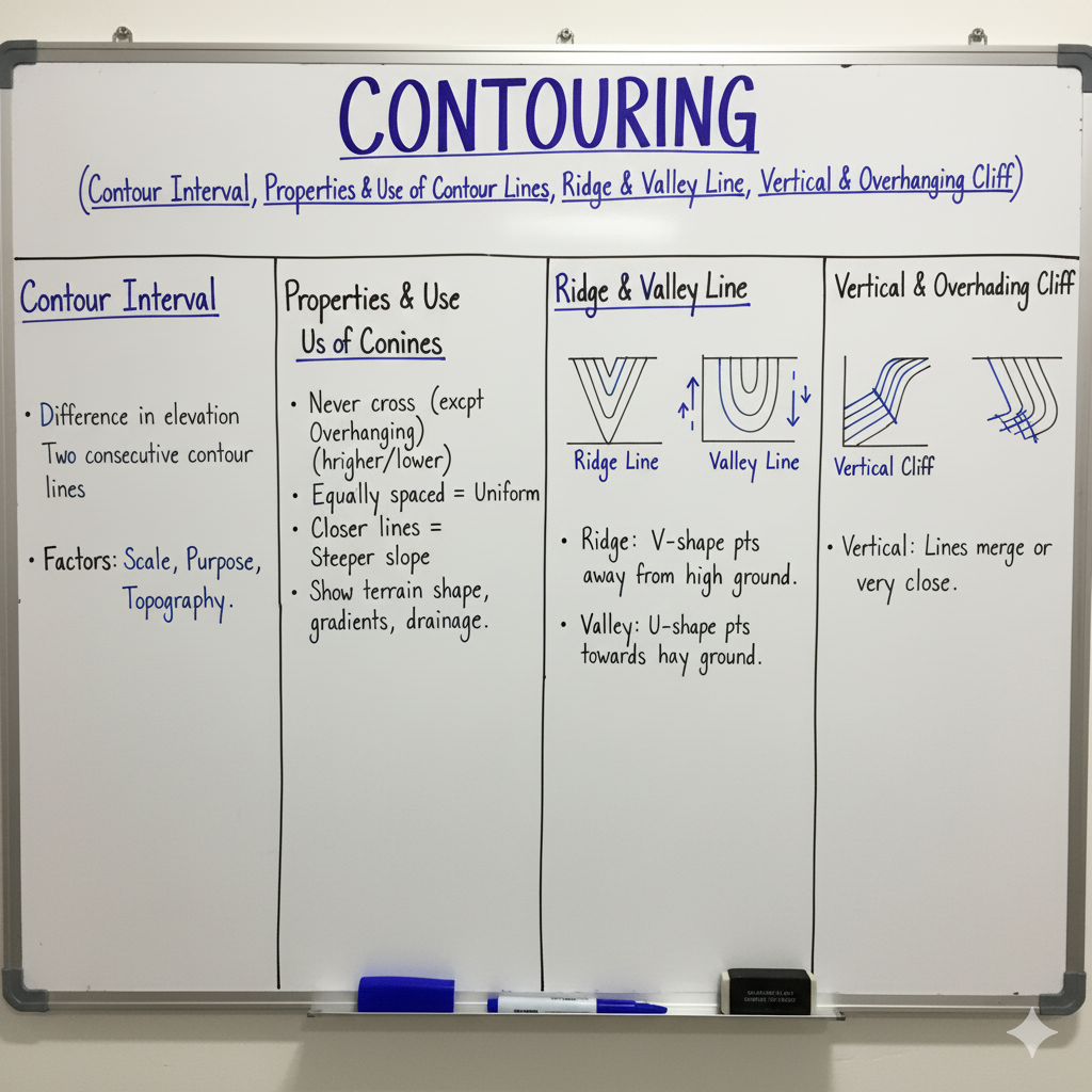
The Contour Interval (C.I.) represents the constant vertical distance between any two successive contour lines. This interval is a typically fixed value for a given map, strategically chosen to range commonly from 1 to 15 meters, influenced by the terrain’s ruggedness and the map’s designated scale. A smaller contour interval unveils a more granular, detailed, and precise analysis of the terrain’s subtle undulations.
Unveiling the Terrain: Fundamental Properties of Contour Lines
Contour lines are not just random markings; they adhere to a precise set of rules and unique characteristics that empower engineers to accurately interpret the complex terrain they gracefully represent.
| Property | Description |
|---|---|
| Equal Elevation | Every single point resting on a given contour line shares the identical elevation above a specified datum. This is their defining characteristic. |
| Closed Curves | Without exception, every contour line must eventually form a closed loop, either fully contained within the map’s boundaries or extending beyond them. They never simply vanish or end abruptly. |
| Non-Intersecting | As a general rule, contour lines do not intersect each other. This is because a single point on the Earth’s surface cannot simultaneously possess two different elevations. The only rare exceptions are geological anomalies like vertical or overhanging cliffs. |
| Non-Merging (Except Vertical Cliff) | Contour lines typically maintain their distinct separation. However, in the extreme case of a perfectly vertical cliff, multiple contour lines may appear to merge or coincide for a very short distance, signifying an abrupt, sheer drop. |
| Spacing & Slope | The spacing between contour lines directly reveals the terrain’s gradient. Closely spaced contours vividly depict a steep slope, while widely spaced contours gracefully indicate a gentle, gradual incline. Perfectly equally spaced contours reveal a uniform, consistent slope. |
| Highest/Lowest Point (Hills & Depressions) | A closed contour line that encloses progressively higher elevation values towards its center unequivocally indicates a hill or a majestic mountain peak. Conversely, a closed contour line encompassing progressively lower elevation values towards its interior signals a depression, a tranquil pond, or a geological pit. |
| Perpendicularity to Steepest Slope | A critical property: contour lines are invariably perpendicular to the lines of steepest slope (lines of maximum gradient) on the ground. This also means that water naturally flows perpendicular to contour lines, following the path of least resistance. |
Reading the Landscape: Interpreting Terrain Features from Contour Maps
Beyond mere elevation, distinct contour patterns paint a vivid picture of specific terrain features, equipping engineers to precisely visualize and understand the landscape in intricate detail.
Ridge Line
A ridge line acts as a crest, connecting the highest points along a hill or elevated ground. On a contour map, these lines elegantly form ‘U’ shapes that bend towards lower ground (appearing convex to lower elevations), serving as a clear indicator of a prominent ridge.
Valley Line
Conversely, a valley line traces the lowest points along a depression or watercourse. Contour lines here distinctively form ‘V’ shapes that bend towards higher ground (appearing convex to higher elevations), with the ‘V’ apex always pointing upstream, revealing the direction of water flow.
Vertical Cliff
The presence of a vertical cliff is dramatically indicated by multiple contour lines appearing to coincide or merge into a single, bold line. This visual phenomenon signifies a sheer, vertical or near-vertical drop where there is virtually no horizontal distance between distinct elevations.
Overhanging Cliff
This is the exceedingly rare and fascinating exception where contour lines actually cross each other. This peculiar intersection on a map distinctly indicates an overhanging cliff, where a point of higher elevation is horizontally situated directly over a point of lower elevation beneath it.
Unlocking Potential: Diverse Uses of Contour Maps in Civil Engineering
Far beyond mere representation, contour maps are truly indispensable tools, guiding critical decisions in the planning, design, and execution phases across a multitude of civil engineering disciplines.
| Application Area | Key Contribution of Contour Maps |
|---|---|
| Site Selection & Planning | Crucially aids in identifying the most suitable sites for groundbreaking construction by offering profound insights into topography, existing slopes, and natural drainage patterns. Indispensable for astute urban planning and initial site feasibility studies. |
| Route Alignment (Roads, Railways, Canals) | Facilitates the precise selection of the most economical and efficient alignment for expansive linear projects. This involves identifying optimal gradients and brilliantly minimizing earthwork volumes, both cuts and fills. |
| Earthwork Volume Calculation | Absolutely crucial for accurately estimating the precise quantities of material to be cut (excavated) and filled (added) for various grading operations, excavation works, and embankment construction. This directly and profoundly impacts project cost estimations. |
| Drainage Design & Hydrology | Empowers engineers to meticulously plan and design highly effective drainage systems by visually tracing natural water flow paths, clearly identifying watersheds, and pinpointing areas intrinsically prone to water accumulation. |
| Reservoir Capacity Estimation | Routinely utilized to determine the exact storage capacity of reservoirs by calculating the immense volumes of water that can be impounded at various distinct contour levels. |
| Slope Analysis & Stability | Enables engineers to rigorously analyze terrain slopes for comprehensive stability assessments, precise landslide susceptibility evaluations, and the robust design of essential retaining structures or strategic cutting slopes. |
| Setting out Gradients | Actively assists in the meticulous laying out of critical infrastructure like roads, sewers, and other linear features with specified gradients and perfectly designed vertical curves. |
| Visibility Analysis | A fundamental tool utilized in military engineering and telecommunications for performing intricate inter-visibility analysis (line of sight studies) between any two designated points on the terrain. |
GATE Exam Practice Questions & Explanations
Sharpen your understanding of Contouring and its practical applications with these challenging GATE-style questions.
1. An imaginary line passing through points of equal elevation on the Earth’s surface is called a:
Answer: Contour line
This is the fundamental definition of a contour line in surveying, serving as the basis for terrain representation.
2. The vertical distance between any two consecutive contour lines is known as:
Answer: Contour Interval
The contour interval (C.I.) is a constant vertical separation between contours, defining the vertical scale of the map.
3. Contour lines usually do not intersect each other. The only exception is in the case of a(n):
Answer: Overhanging cliff
An overhanging cliff is the singular geological feature where a higher elevation literally hangs over a lower one, forcing contours to visually cross on a 2D map.
4. Closely spaced contour lines indicate:
Answer: A steep slope
When contours are tightly packed, it signifies a rapid change in elevation over a short horizontal distance, hence a steep gradient.
5. A closed contour line with higher elevation values inside represents a:
Answer: Hill or mountain
Tracing inwards on such contours leads to increasing elevation, characteristic of a topographic high point like a hill or peak.
6. Contour lines form ‘V’ shapes that point towards higher ground. This indicates a:
Answer: Valley line
The V-shape of contours in a valley always points upstream, towards the origin of water flow, which is typically at a higher elevation.
7. The process of estimating earthwork volumes (cut and fill) is a major application of:
Answer: Contour maps
By analyzing areas between contours, engineers can accurately calculate volumes of soil/rock to be excavated or filled, crucial for cost and material estimation.
8. Contour lines are always perpendicular to the:
Answer: Lines of steepest slope
This fundamental property means that water flow (following the steepest path) will always cut across contour lines at right angles.
9. If multiple contour lines appear to merge into a single line, it indicates a(n):
Answer: Vertical cliff
A vertical cliff implies that numerous elevations exist at essentially the same horizontal position, causing their respective contour lines to coalesce.
10. A closed contour line with lower elevation values inside represents a:
Answer: Depression or pond
Conversely to a hill, tracing inwards on such contours reveals decreasing elevation, indicating a hollow, basin, or pit.
11. What is the usual range of contour interval for a general topographical map?
Answer: 1 to 15 meters
The specific interval is a design choice dependent on factors like the map scale, the intended use, and the ruggedness of the terrain being mapped.
12. Contour lines form ‘U’ shapes that point towards lower ground. This indicates a:
Answer: Ridge line
The ‘U’ shape of contours on a ridge bends downwards towards the decreasing elevations, signifying a projecting feature of higher ground.
13. For planning and designing dams, reservoirs, and aqueducts, which surveying output is most crucial?
Answer: Contour maps
Contour maps are indispensable for hydrological studies, calculating immense water volumes, and determining optimal placement and design of water infrastructure.
14. If contour lines are parallel and equally spaced, what type of slope do they represent?
Answer: Uniform slope
Even spacing between parallel contours denotes a consistent gradient across that particular section of the terrain.
15. What happens to contour lines in a perfectly vertical cliff?
Answer: They coincide or merge
A vertical cliff means that multiple discrete elevations exist at effectively the same horizontal coordinate, causing their corresponding contour lines to visually coalesce.
16. The ideal size of a contour interval for rugged and mountainous terrain would generally be:
Answer: Larger
A larger interval (e.g., 10m or 15m) prevents map clutter and maintains readability in areas characterized by rapid and significant elevation changes.
17. Which application uses contour maps to analyze line of sight for military or communication purposes?
Answer: Visibility analysis
Contour maps are fundamental for assessing inter-visibility between points, crucial for tactical planning, surveillance, and optimal placement of communication towers.
18. If a stream flows in a valley, the V-shape of the contour lines will point:
Answer: Upstream
The apex of the ‘V’ formation in valley contours consistently points towards the higher elevation, indicating the direction from which the water originates or flows.
19. A contour map can directly help in deciding the location for a new industrial plant by showing:
Answer: Suitable terrain, drainage, and accessibility related to ground slopes.
Contour maps provide indispensable topographical intelligence for strategic site selection and efficient layout planning, considering factors like optimal land use, natural drainage, and construction feasibility.
20. The degree of detail presented by a contour map is primarily influenced by its:
Answer: Contour interval
A finer, smaller contour interval results in a greater number of contour lines being drawn for the same area, thereby offering a significantly more detailed and granular representation of the terrain’s nuances.