What Are Road Network Patterns?
A road network pattern refers to the geometric layout of roads within a city, town, or rural region. The choice of pattern significantly affects traffic flow, land use efficiency, and overall accessibility. Civil engineers and town planners evaluate multiple options before selecting the most appropriate one for a given region.
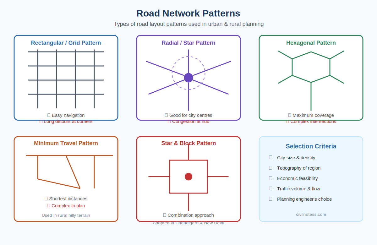
1. Rectangular or Grid Pattern
The rectangular grid consists of streets intersecting at right angles, forming uniform rectangular blocks. It is the most widely adopted layout globally — found in cities like New York, Chandigarh, and many older Indian towns.
- Advantages: Easy navigation, simple to plan, uniform block sizes for property subdivision
- Disadvantages: No diagonal movement possible; all roads carry equal traffic; not suitable for hilly terrain
2. Radial or Star Pattern
Roads radiate outward from a central hub like spokes on a wheel. Common in European cities and provides efficient access to city centres from all directions.
- Advantages: Excellent connectivity to the centre; reduced travel distance from periphery to hub
- Disadvantages: Severe congestion at the central point; peripheral movement is difficult without ring roads
3. Hexagonal Pattern
The hexagonal pattern is a theoretical design providing maximum area coverage with the least total road length. Rarely implemented in pure form but influences smart city and network optimization concepts.
- Advantage: Maximum area coverage per unit of road length
- Disadvantage: Very complex intersections; impractical for large-scale implementation
4. Minimum Travel Pattern
Designed to minimize total travel distance for all residents. Particularly useful in rural and hilly regions where roads must follow natural contours and population distribution dictates routes.
5. Star and Block Pattern
This hybrid combines radial roads for city centre access with rectangular blocks in between. Adopted in well-planned Indian cities like Chandigarh and the Connaught Place area of New Delhi.
- Reduces centre congestion by providing ring roads
- Best for cities with a defined central business district
- Combines the best features of radial and grid patterns
Factors Governing Pattern Selection
| Factor | Influence on Pattern Choice |
|---|---|
| City Size | Larger cities need multiple rings + radials |
| Topography | Hilly terrain favours organic or minimum travel patterns |
| Traffic Volume | High traffic demands arterial grid or radial systems |
| Economic Capacity | Simpler grids cost less to build and maintain |
| Existing Development | Must integrate with current built environment |