Levelling is a fundamental surveying operation dedicated to determining the relative elevations of points on the Earth’s surface. Achieving high precision in levelling is critical for infrastructure projects, requiring meticulous attention to instrumental and environmental factors. This infographic delves into essential corrections for curvature and refraction, explains the concept of the visible horizon, details the advanced technique of reciprocal levelling, and outlines common sources of errors, all vital for civil engineers.
Introduction to Levelling
Levelling is the process of measuring differences in elevation between various points on the Earth’s surface. It plays a crucial role in planning and constructing roads, railways, canals, buildings, and drainage systems, where maintaining specific gradients and vertical clearances is paramount. All elevations are typically referenced to a common datum, most often the Mean Sea Level (MSL).
Essential Corrections in Levelling
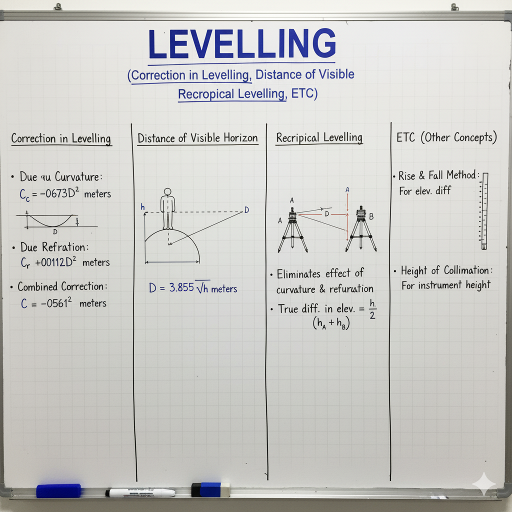
For precise levelling, especially over long distances, corrections must be applied to account for the Earth’s curvature and atmospheric refraction, as the line of sight is not perfectly horizontal.
| Correction Type | Description | Formula | Nature |
|---|---|---|---|
| Correction for Curvature (Cc) | Due to Earth’s curvature, the line of sight is tangential to the level surface at the instrument. The staff reading will be more than the true reading. | Cc = 0.0785 D2 (where D is distance in km) |
Always Subtractive (-) |
| Correction for Refraction (Cr) | Due to atmospheric refraction, the line of sight is bent downwards towards the Earth. This causes the staff reading to be less than the true reading. | Cr = 0.0112 D2 (where D is distance in km) |
Always Additive (+) |
| Combined Correction (C) | The net effect of curvature and refraction. Since refraction counteracts curvature, the combined correction is the difference between them. | C = Cc – Cr = 0.0673 D2 (where D is distance in km) |
Always Subtractive (-) |
Distance of Visible Horizon
The distance of the visible horizon refers to how far one can see along the Earth’s surface from a given height, factoring in the Earth’s curvature and atmospheric refraction.
| Concept | Description | Formula |
|---|---|---|
| Distance of Visible Horizon (D) from a single point | The maximum distance to which an object can be seen from a height ‘h’ above the Earth’s surface. | D = 3.855 × sqrt(h) (where D is in km and h is in meters) |
| Inter-visibility between two points | Determining if two points of given heights are mutually visible. The distance between them must be less than the sum of their individual visible horizons. | Dtotal ≤ D1 + D2 (D1 from height h1, D2 from height h2) |
Reciprocal Levelling: Crossing Obstacles Precisely
Reciprocal levelling is a highly accurate method used to determine the true difference in elevation between two points that are separated by a wide obstacle (e.g., river, valley) where setting up the level midway is impossible. This technique effectively eliminates errors due to curvature, refraction, and collimation.
Procedure & Advantages
- Set up the level near point A and take staff readings on A (BSA1) and B (FSB1).
- Move the level to a position near point B and take staff readings on B (BSB2) and A (FSA2).
- The true difference in elevation (H) between A and B is the average of the two apparent differences.
True Difference in Level (H) = [(BSA1 – FSB1) + (BSB2 – FSA2)] / 2
Advantages:
- Eliminates errors due to **curvature** and **refraction** because they affect both readings equally.
- Eliminates error due to **collimation line** (line of sight not being parallel to the axis of the bubble tube).
- Eliminates errors due to **imperfect leveling** of the instrument.
Sources of Errors in Levelling
Errors in levelling can arise from various sources, affecting the accuracy of elevation determination. Identifying and mitigating these errors is crucial for reliable results.
| Error Category | Examples/Causes | Mitigation Strategies |
|---|---|---|
| Instrumental Errors | Collimation error (line of sight not horizontal), axis of bubble tube not parallel to line of sight, loose tripod, defective staff. | Regular instrument calibration, proper reciprocal levelling, careful handling. |
| Natural Errors | Curvature of Earth, atmospheric refraction, temperature variations, wind, sun’s glare, settlement of tripod/staff. | Applying corrections, reciprocal levelling, shielding instrument, using stable setups. |
| Personal Errors | Improper levelling of instrument, inaccurate staff readings, incorrect booking, not holding staff vertical, parallax error. | Training, careful observation, proper technique, using a spirit level on staff. |
GATE Exam Practice Questions & Explanations
Test your understanding of levelling corrections, visible horizon, and reciprocal levelling with these GATE-style questions.
1. The correction for curvature in levelling is:
Answer: Always subtractive
Due to Earth’s curvature, the staff reading is always higher than the true reading, so the correction must be subtracted.
2. If the distance between the levelling instrument and the staff is 1 km, the correction for curvature is approximately:
Answer: 0.0785 m
Cc = 0.0785 D2. For D = 1 km, Cc = 0.0785 * (1)2 = 0.0785 m.
3. Which error in levelling is always additive to the staff reading?
Answer: Correction for Refraction
Atmospheric refraction bends the line of sight downwards, making the staff reading appear less than it actually is. Hence, the correction is added.
4. Reciprocal levelling is performed to eliminate the effects of:
Answer: Curvature, refraction, and collimation error.
This technique effectively cancels out these systematic errors by taking readings from both ends of the line across an obstacle.
5. The combined correction for curvature and refraction is approximately:
Answer: 0.0673 D2
C = Cc – Cr = 0.0785 D2 – 0.0112 D2 = 0.0673 D2.
6. The distance of visible horizon from a point at height ‘h’ (in meters) above the ground is given by:
Answer: D = 3.855 × sqrt(h) (where D is in km)
This formula directly calculates the visible distance considering the combined effect of curvature and refraction.
7. What is a primary source of instrumental error in levelling?
Answer: Collimation error
Collimation error occurs when the line of sight is not truly horizontal, despite the bubble being centered.
8. If the line of sight is bent downwards due to atmospheric conditions, this is an effect of:
Answer: Atmospheric refraction
Refraction causes light rays to bend as they pass through different densities of air in the atmosphere.
9. Reciprocal levelling is particularly useful when levelling across:
Answer: A river or a gorge
These wide obstacles make it impossible to set up the level exactly midway, which is the ideal scenario for simple differential levelling.
10. The true difference in level in reciprocal levelling is given by the average of:
Answer: The two apparent differences in level (from each instrument station).
Averaging cancels out the errors inherent in each observation from different setups.
11. A negative sign for correction indicates that the measured value is:
Answer: Greater than the true value
A negative correction means you subtract from the measured value to get closer to the true value.
12. Which error type includes incorrect staff readings or improper levelling of the instrument?
Answer: Personal Errors
These errors arise from the surveyor’s handling or judgment during the operation.
13. The standard value for the radius of Earth used in curvature correction formula is approximately:
Answer: 6370 km
While not explicitly in the provided text, this is the standard value used to derive the 0.0785 coefficient for curvature correction.
14. What is the effect of wind on levelling operations?
Answer: Causes vibration of the staff and instrument, leading to inaccurate readings.
Wind is a natural error source that can make precise sighting and reading difficult.
15. If the observed staff reading is 2.500m and the combined correction is -0.050m, the corrected staff reading is:
Answer: 2.450m
Corrected Reading = Observed Reading + Correction = 2.500 + (-0.050) = 2.450m.
16. The settlement of the tripod or staff during observation is a type of:
Answer: Natural error
This is a natural phenomenon related to ground conditions or temperature changes, not directly due to instrument defect or personal mistake.
17. In reciprocal levelling, setting up the instrument exactly at the midpoint of the line is:
Answer: Not possible, hence reciprocal levelling is needed.
The primary reason for using reciprocal levelling is when the obstacle prevents a midway setup, as a midway setup would automatically eliminate curvature and collimation errors.
18. The datum commonly used for establishing elevations in large-scale surveys is:
Answer: Mean Sea Level (MSL)
MSL provides a standardized, globally recognized reference for vertical measurements.
19. If the coefficient of refraction is taken as 0.0112, what percentage of curvature correction is refraction correction?
Answer: Approximately 1/7th or 14%
0.0112 / 0.0785 ≈ 0.142 or 1/7. This indicates that refraction is about 1/7th of the curvature effect and acts in the opposite direction.
20. Which of the following errors is eliminated if the staff is held perfectly vertical during levelling?
Answer: Error due to non-vertical staff
If the staff is tilted, the reading will be higher than the true vertical reading. Holding it vertical eliminates this personal error.